Guide to Florida Hurricane Season
Have you ever wondered why Florida, the Sunshine State, is often at the epicenter of swirling storms and dramatic weather updates? It all comes down to one key time frame: hurricane season. Understanding this period is crucial for anyone living in, visiting, or planning to move to Florida.
When is Hurricane Season in Florida?
The Atlantic Hurricane Season, a widely recognized period running from June 1 to November 30, is a phase of heightened tropical storm activity. These storms, which may escalate into hurricanes, generally form over the Atlantic Ocean, the Gulf of Mexico, and the Caribbean Sea. The chosen start and end dates reflect the historical occurrence pattern of these storms, which tend to peak during this six-month window.
Why these specific dates, you might ask? The answer lies in a convergence of atmospheric and oceanic conditions that serve as a perfect cauldron for hurricane development.
First, let’s delve into ocean temperatures. For a hurricane to form, the sea surface temperature generally needs to be above 79 degrees Fahrenheit. This heat fuels the storm, providing the energy and moisture that drive its development. During the designated hurricane season, a large expanse of the Atlantic Ocean, especially the tropical Atlantic, reaches or surpasses this critical temperature threshold.
Atmospheric conditions during this season are also primed for hurricane formation. For instance, wind shear — the change in wind speed and direction with height — is relatively low during this period. High wind shear can inhibit a hurricane’s development by tearing it apart. However, during the Atlantic hurricane season, these disruptive winds are typically at their weakest, thereby encouraging storm formation and intensification.
Lastly, the phenomenon known as the African Easterly Jet comes into play. During the summer months, this wind pattern generates disturbances off the west coast of Africa, which can eventually organize into tropical storms and hurricanes as they move westward across the Atlantic.
However, it’s important to note that while hurricane activity is heightened between June and November, this does not render the rest of the year hurricane-free. Storms can — and do — form outside this official window, if the requisite conditions materialize. This underscores the need for constant vigilance and preparedness, as nature doesn’t always stick to human-defined schedules.
What is an Atlantic Hurricane?
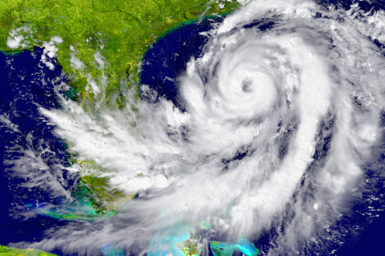
In essence, an Atlantic hurricane is a massive storm that forms in the Atlantic Ocean, characterized by strong winds spiraling around a calm center known as the eye. These formidable forces of nature get their start over warm ocean waters and can wreak chaos when they make landfall, causing heavy rainfall, violent winds, and even destructive tornadoes.
Florida’s historical record brims with notable hurricanes. From the catastrophic Labor Day Hurricane in 1935 to the more recent Hurricane Irma in 2017, the state has weathered numerous storms, each leaving a lasting impact on its people and landscape.
Key Details of Hurricanes in Florida
For Floridians, the hurricane season, running from June 1 through November 30, is a time of heightened alertness. However, within this six-month period, there’s a span where the state faces an elevated risk. Historical weather data reveals that peak hurricane activity in Florida tends to cluster between mid-August and late October. This period is often referred to as the “peak of the peak,” signifying the time when the most potent and numerous storms are likely to occur.
The geographical position of Florida, nestled between the Atlantic Ocean on the east and the Gulf of Mexico on the west, combined with its extensive coastline, makes it a prime target for hurricanes. The state’s low-lying topography also contributes to its vulnerability, especially when it comes to storm surges and flooding.
Hurricanes that threaten Florida typically form off the coast of Africa, initiated by a weather phenomenon known as African Easterly Waves. These disturbances travel westward across the warm waters of the tropical Atlantic, where they have the potential to organize into tropical storms and eventually hurricanes.
Once formed, these storms’ trajectories are influenced by large-scale weather patterns. The Atlantic Subtropical High, also known as the Bermuda High, plays a significant role here. Depending on its position and strength, it can steer these storms toward Florida. Moreover, prevailing wind patterns generally push these systems westward, further increasing the likelihood that Florida lies in their path.
Additionally, hurricanes can form in the Gulf of Mexico and Caribbean Sea, other areas where the water temperatures are warm enough to fuel these storms. In these cases, Florida can be a target as these storms move northward or westward, steered by similar large-scale weather patterns.
In short, the combination of Florida’s geography, its extensive coastline, and the prevailing weather patterns make it a frequent player in the annual drama that is the Atlantic hurricane season. The state’s residents are thus no strangers to the protocols of hurricane watches and warnings, storm-proofing homes, and, when necessary, evacuating ahead of an approaching storm.
Phases of Hurricane Development
Before a hurricane roars to life, it goes through several stages. It begins as a tropical disturbance, where thunderstorms cluster over warm ocean waters. Once this system develops a closed wind circulation, it’s deemed a tropical depression.
As the depression strengthens, it may evolve into a tropical storm, earning a name from the official list compiled by the World Meteorological Organization. If the storm continues to intensify, with winds reaching 74 miles per hour or higher, it graduates to a hurricane.
Hurricanes are then categorized using the Saffir-Simpson scale, ranging from Category 1 (the least severe) to Category 5 (the most destructive), based on their wind speed.
Preparation and Safety Measures during Hurricane Season
Preparing for hurricane season isn’t something to take lightly. First and foremost, make a plan. Know where you’ll go if you have to evacuate, pack an emergency kit, and keep a list of important contacts handy.
Maintaining your home is another essential step in preparing for hurricane season. Trim trees and secure loose outdoor items that could turn into dangerous projectiles in strong winds.
If a hurricane watch or warning is issued, pay close attention to local weather updates and official instructions. A watch means conditions are possible within 48 hours, while a warning indicates that conditions are expected within 36 hours.
Remember, if you live in an evacuation zone and an order is given, leave. No possessions are worth risking your life.
Post-Hurricane Procedures
In the immediate aftermath of a hurricane, safety remains the top priority. Steer clear of downed power lines, and be aware of hazards like sharp debris or potentially unstable structures.
Assessing property damage should be your next step. Document any damage thoroughly with photos or videos to facilitate insurance claims.
After a hurricane, it’s important to connect with your community. Local authorities, charities, and organizations often provide essential resources for recovery, like food, water, shelter, and cleanup supplies.

Keep Your Home Protected during the Florida Hurricane Season
At Paradise Exteriors, we offer a complete exterior protection solution for your home to withstand even the most severe hurricane activity in South Florida. With industry leading hurricane-rated window, door, and roofing protection systems, you can relax with the peace of mind that your home is always ready to protect itself from intense weather, regardless of whether it’s hurricane season or another time of year.
To get started, request your Free Quote.


